A Wikipedia for Street Names

Earlier this week, the Department of Records and Information Services (DORIS) launched an interactive map, accessible on both desktop and mobile devices, to help people connect with the stories behind nearly 2,500 co-named streets, intersections, parks and other locations throughout the City.   

NYC Honorary Street Names Map. Department of Records and Information Services, 2024. 

Perhaps you’ve seen the markers. They are usually attached to a signpost just beneath the street name. For example, a sign at the corner of Park Row and Spruce Street in Manhattan informs us that it is co-named “Elizabeth Jennings Way.”  By clicking that location on the map you will learn that the City Council designated Park Row between Beekman and Spruce Streets in honor of Jennings, a Black teacher who integrated the City’s trolleys in 1854 by refusing to “get off” when instructed.

Just a block away, at the northeast intersection of Park Row and Beekman Street, a sign says it is also known as Susan B. Anthony and Elizabeth Cady Stanton Corner. Map users will find out that in 2004 the Council honored the two women’s suffrage pioneers for their contributions to gender equality.

Street Sign, Susan B. Anthony & Elizabeth Cady Stanton Corner, 2024.

The origins of the map initiative date to 2023 when the New York City Council passed legislation sponsored by Councilmember Gale Brewer mandating online access to biographical and/or background information about persons or entities honored by the Council with a co-named street, intersection, park, or playground.

Mayor Eric Adams designated DORIS as the agency responsible for posting co-named street information on its website. Initially, DORIS published the City Council local laws containing the information online in the Government Publications Portal. To make the co-named street data more accessible, the agency’s application developers and interns created an interactive map that people walking around the city can access on their phones.

Street Sign, Elizabeth Jennings Place, 2024.

Using mapping software from the Office of Technology and Innovation (OTI), DORIS’ application developers built the map. They created a form to enter the biographical or background information contained in local laws termed “street renaming bills” that have been passed by the City Council between 2001 and the present. The data on the form is linked to the appropriate location on the map. During the summer of 2024, a team of interns from CUNY and the PENCIL programs  transferred  the data about locations and each of the 2,496 individuals into the form.

The map is searchable by the name of the individual, zip code, and categories such as “firefighter” or “police officer.” So far, there are 1,610 co-named intersections, and 886 co-named streets.

Residents of the Astoria neighborhood in Queens are not likely to be surprised by the co-named Tony Bennett Place at the intersection of 32nd Street and Ditmars Boulevard. The co-naming by the Council in 2024 honored Astoria-native Bennett for his lifetime in music that included 20 Grammy Awards, and more than 50 million records sold worldwide.

NYC Honorary Street Names Map, Lieutenant Theodore Leoutsakos Way, Astoria, Queens. Department of Records and Information Services, 2024. 

Not all co-named streets honor famous people. For example, there is Lieutenant Theodore Leoutsakos Way, just two blocks away from Tony Bennett Place, at the intersection of 29th Street and 21st Avenue in Astoria. In 2016, the Council honored Lt. Leoutsakos for his service as a first responder during the 9/11 terrorist attacks at the World Trade Center. A United States Air Force Veteran who served during the Vietnam War, Leoutsakos was diagnosed with pancreatic cancer as a result of his time spent at Ground Zero. The diagnosis came shortly after he retired from 24 years as a New York State Court Officer.

In 2002 and 2003, local laws enacted by the City Council included co-named streets for more than 400 first responders killed on 9/11. Many of those streets lack biographical information. DORIS is working with the Council to gather the biographical information for inclusion in upcoming local laws.  The information will subsequently be added to the map.

NYC Honorary Street Names Map, Tillie Tarantino Way, Williamsburg, Brooklyn. Department of Records and Information Services, 2024. 

In the event that you detect an error in the biographical information, contact your local City Councilmember. Changes to the information on the map will be made after the Council includes the correction in a new street renaming law. 

If a sign with the name of the co-named street is missing from its designated location, go to nyc.gov/311 or call 311 to report it.

DORIS will continue to add data to the online map, using the information in local laws pre-dating 2001.

At the launch of the map, Councilmember Gale Brewer remarked that “Our City’s history is long and deep, and we need tools to remember those who came before us—whether their name is on a building or on a street sign—and why they’re being honored. Think of this as Wikipedia for street names!”

Yankees v. Dodgers v. Giants

Baseball fans know that the Yankees v. Dodgers games this week were not the first time the two faced off in the World Series. In 1941, the Yankees vanquished the Dodgers four games to one. At their next meeting in 1947, the Yankees won again, four games to three. The two teams dueled ten more times, most recently in 1981, when the Dodgers won the trophy four games to two.   

Double Header, April 14, 1943, Poster. Mayor Fiorello LaGuardia Collection. NYC Municipal Archives.

Perhaps less well-remembered is a pre-season tournament with the Yankees, Dodgers and Giants. It took place on April 15, 1943, as a benefit for the Civilian Defense Volunteer Office. At that time all three teams were New York-based—the Yankees in The Bronx, the Giants at the Polo Grounds in Manhattan, and the Dodgers at Ebbets Field, Brooklyn. In the benefit match, the Yankees battled the Dodgers in the first game; the Giants played the winner in the second.        

President Roosevelt established the Office of Civilian Defense on May 21, 1941, and appointed Mayor LaGuardia as its National Director. LaGuardia held this position until the end of World War II. The Office was tasked with alerting and educating the public about civilian defense, organizing volunteer groups, and training fire protection and bomb disposal units in anticipation of damage caused by air raids. 

Mayor Fiorello LaGuardia’s records provide context for the benefit tournament. His collection is organized into twenty-one series such as departmental, general and subject files. In addition, there are two series, the Office of Civilian Defense (OCD), and the related Office of Civilian Defense Volunteer Office (CDVO), relevant to research on the topic.  

The OCD series includes a folder of documents concerning the benefit game. One informative item is a draft statement from the Mayor appealing to all New Yorkers to support the CDVO by buying tickets to the baseball series to be played at Yankee Stadium starting at one p.m. on April 15, 1943  The statement quotes LaGuardia: “CDVO is doing a great job... and deserves the support of every New Yorker. Men and women volunteers are giving freely of their time and energies in undertaking the many home-front tasks occasioned by the war. CDVO up to now has been run on voluntary contributions but money is needed urgently to carry on the work.”    

The folder also contains carbon copies of letters LaGuardia sent to heads of City agencies requesting the release of designated employees to help with ticket sales. The only blip in the preparations appears to have been in the New York City Housing Authority. A telegram to the Mayor from “Painters NYC HA,” dated April 13, just two days before the tournament explained the situation: “Please be informed that painters of NYC Housing Authority have been refused permission to attend baseball game April 15 while office force of same authority have been granted same permission. Strongly protest this flagrant discrimination.” The next day, April 14, LaGuardia received a letter from Edmond Borgia Butler, Chairman of the New York Housing Authority: “As you know, our painters and other maintenance employees work on a rigid schedule, which must be maintained if the necessary services are to be supplied tenants in our projects. Except for these employees and the administrative staff, all other employees were permitted to be absent to attend the baseball.” 

Telegram, April 13, 1943. Mayor Fiorello LaGuardia Collection. NYC Municipal Archives

The file does not include LaGuardia’s response to these missives.  

Whether or not Housing Authority painters attended the game may never be known, but 35,301 spectators did witness the tournament, according to the New York Times. The Times story related how the Brooklyn team vanquished the Yankees, six to one, and then went on to defeat the Giants, one to zero. In the words of Times reporter John Drebinger: “In an era of considerable scarcity the Dodgers simply had too much of everything yesterday as they crowned themselves the so-called “mythical” baseball champions of Greater New York by polishing off both the Yankees and Giants in the CDVO double-header at the Stadium before a gathering of 35,301 frostbitten but highly enthusiastic onlookers.”  

In his statement Mayor LaGuardia added “The Presidents of the Yankees, Dodgers, and Giants ball-clubs have generously donated the net proceeds of these two games to CDVO and it is up to all of us to make April 14th the greatest day in baseball history.”   


Race to the Top

Municipal archivists processing records in the Manhattan Building Plans collection recently discovered blueprints submitted to the Department of Buildings in 1929 for construction of the Empire State Building. Completion of the iconic building in 1931 capped a mad race to build the tallest skyscraper in the world, and Municipal Archives collections help tell the story. 

Empire State Building, 5th Avenue Elevation. Dept. of Buildings Plans, NYC Municipal Archives.

Woolworth Building from 27th floor of Municipal Building (short focus), October 22, 1914. Eugene de Salignac, photographer. Dept. of Bridges/Plant & Structures Collection, NYC Municipal Archives.

Just as the stock market soared to new heights in the 1920s, so too did the height of the skyscraper. The race to construct the tallest building in the world that began in the second half of the decade, was not the first in New York City history. In 1908, the Metropolitan Life Insurance tower on Madison Square outdistanced the Singer Building, completed only eighteen months earlier. The 1913 Woolworth Building eclipsed both, rising 692 feet into the sky.

The 1916 New York Zoning ordinance, World War I, and a post-war recession halted further competition for nearly a decade. By the 1920s, amidst rising prosperity, and in an age that extolled record-breaking builders sought to surpass the “Cathedral of Commerce.”

The headline on the front page of The New York Times on June 25, 1925, signaled resumption of the race for the tallest structure: “42-Story Office Building... To Go Up In West 42nd St.” The story added that real estate speculator John Larkin declared his building would be the tallest structure in New York north of the Metropolitan tower, “and the largest building operation ever undertaken near the Times Square section.”

Just three months later, on September 1, 1925, the Times front page announced another super-tall building: “65-Story Hotel Here to be Part Church.” The tower, planned as part church and part hotel, would rise in upper Manhattan, on Broadway, between 122nd and 123rd Streets. Clearly designed to best the Woolworth Building it would exceed the lower Broadway structure by only 8 feet. The building developer, Oscar E. Konkle, President of Realty-Sureties, Inc. planned the unusual church-hotel com­bination to express his gratitude for the life of his son, who had miraculously recovered from a nearly fatal disease. Konkle announced that ten percent of the profits would be devoted to missionary work and that none of the occupants of the hotel would be permitted “to smoke or use tobacco, or drink intoxicants on the premises, from which it [was] also announced, Sunday newspapers may be eliminated.”

Lower Manhattan Skyscrapers, 1937. James Suydam, photographer. WPA Federal Writers’ Project Collection, NYC Municipal Archives.

Perhaps needless to say, this noble edifice was not built. In a follow-up story, on June 14, 1926, the Times reported: “Possibly the promoter has despaired of finding... New Yorkers willing to do without Sunday newspapers and pledging themselves to abstain even from solitaire in the privacy of their own chambers.”

Chrysler building under construction, 1930. FDNY Collection, NYC Municipal Archives.

Larkin’s building also failed to materialize, but in September 1926, he announced plans for a gargantuan 110-story building on his 42nd Street plot. His comments concerning this behemoth were revealing: “It has been asked of us why we chose to design this building taller than other buildings... but we did not set out to accomplish this specific result. We simply endeavored to provide the greatest amount of permanent light and air to the greatest possible proportion of floor area with a surplus of elevator service. The projected building came naturally out of these conditions.” (New York Times, December 5, 1926.)

Whether economics “naturally” dictated a 110-story building is debatable; in any case, Larkin’s tower, like the Konkle Church on Morningside Heights only existed in the imaginations of their builders. Woolworth’s monument remained secure in its position as highest in the world. Nevertheless, it was clear that the race was on in earnest.

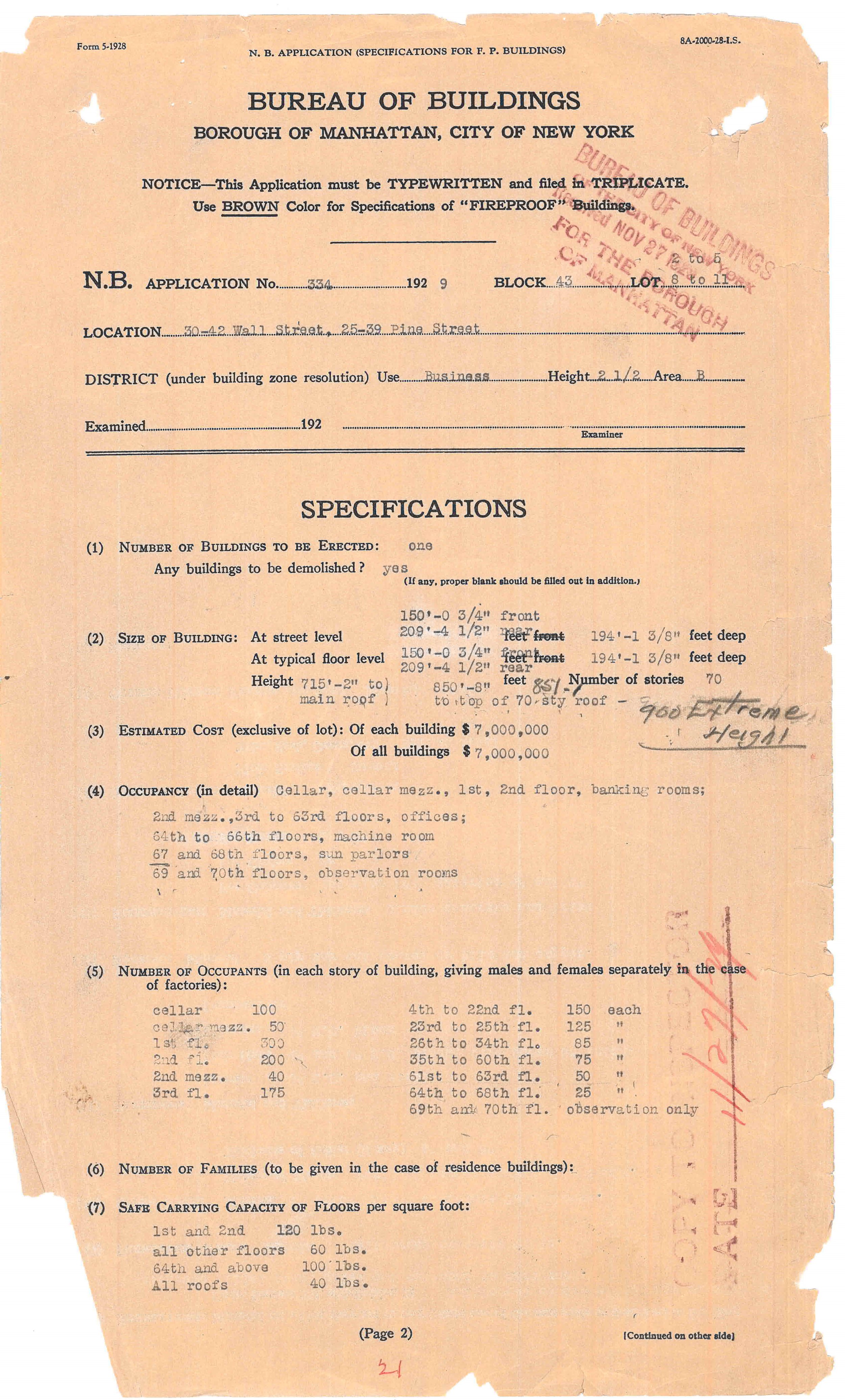
Bank of Manhattan, New Building Application, 30-42 Wall Street, 1929. Dept. of Buildings Manhattan Permit Collection.

On February 16, 1928, former Senator William H. Reynolds, President of the Reylex Corporation, filed plans with the Department of Buildings for a 63-story building on Lexington Avenue at 42nd Street that would ascend to a height of 755 feet, about 40 feet less than the Woolworth building. A few days later Reynolds filed revised plans with the Buildings Department that stretched the skyscraper 53 feet to make it 808 feet tall, 16 feet higher than Woolworth. Before construction began, however, in October 1928, Reynolds sold his leasehold to automobile mogul Walter Chrysler. (New York Times, February 2, 8; October 17, 1928.)

In 1929, a new headquarters for the Bank of Manhattan Company on Wall Street loomed as another potential contestant in the skyscraper sweepstakes. According to the New Building application specifications on file in the Archives’ Manhattan Building Permits collection, it would be a 564 foot, 47-story tower. Revised plans submitted in April 1929, stated the building would be 60-stories and 715 feet high; still less than Chrysler’s 42nd Street tower.

The race was far from over. The next actor in this drama was Alfred E. Smith, the former Governor of New York State and unsuccessful presidential candidate. Again, the front page of the Times carried the announcement: “Smith to Help Building Highest Skyscraper.” The story explained that Smith would be President of a company that would build the highest office tower in the world on the site of the Waldorf Astoria Hotel, at 5th Avenue and 34th Street. (August 30, 1929.)

Empire State Building, 33rd and 34th Street Elevations, Sub-basement to 39th floor. Dept. of Buildings Plans, NYC Municipal Archives.

According to the entry in the Archives’ Building Department docket book collection, the developers filed plans on January 22, 1929, for a 55-floor skyscraper. By August the height had been increased to 60-stories. Although Smith denied that the plans were altered so that the building, later named the Empire State Building, would be tallest in the world, his denial seems unpersuasive in view of the circumstances. (New York Times, August 30, 1929.) 

National City Bank-Farmers Trust Company building, New Building Application, 1930. Dept. of Buildings Manhattan Permit Collection.

In October of 1929, just as the stock market began to falter, two more giant skyscrapers entered the race. First, the National City Bank-Farmers Trust Company filed plans with the Buildings Department for a 66-floor tower that would climb 845 feet in Manhattan’s financial district, higher than both the Chrysler and Bank of Manh­attan buildings. Two days later, A. B. Lefcourt announced that he would construct a 1,050 foot tower in Times Square which would push up 50 feet higher than the Empire State Building. (New York Times December 18,1929.) 

Both these structures became early casualties of the Stock Market crash. The Lefcourt tower never progressed further than the front­ page announcement in the Times. The National City Bank building was constructed, but significantly reduced in scale. Nevertheless, both skyscrapers were a potential threat in the race and spurred the finalists on to even greater heights.

By late 1929, the Chrysler Building reached 861 feet high. Believing that to be the final height, the Bank of Manhattan altered their plans by adding a “sun parlor” and observation rooms capped with a lantern sporting a flagpole that increased its height to 925 feet. Bank builder, Paul Starrett, President of Starrett Brothers, Inc., denied that the plans had been altered, saying his company “was not competing for height supremacy in building.” (New York Times October 20, 1929.) But specifications on file in the Permits collection indicate that they were indeed amended.

Night View Midtown Manhattan, shows the Chrysler and Empire State, ca. 1937. WPA Federal Writers’ Project Collection, NYC Municipal Archives.

When Walter Chrysler and his architect William Van Alen realized that the Bank of Manhattan Company tower would exceed their building in height, they conceived the idea of secretly constructing a “supplemental vertex” (actually a modernistic flagpole) inside the fire tower, and when completed, lifting it to the crown of the building. The result was that the Chrysler tower secured the coveted title of tallest structure in the world. (New York Times, February 9, 1930).

Empire State Building, Elevations of Observation Tower. Dept. of Buildings Plans, NYC Municipal Archives.

Empire State Building observation tower, 1941. WPA Federal Writers’ Project Collection, NYC Municipal Archives.

Their victory was short-lived, however. The surprise addition to the Chrysler tower prompted the Empire State group to add a “dirigible mooring mast” to the top of their building. It is debatable whether the mooring mast could have ever been practicable, but it made the building 1,300 feet tall, safely taller than all rivals. Two unsuccessful attempts to anchor dirigibles were made after the building opened, but it became much more profitable as an observation deck. (New York Times, July 21, 1930.)

And so the race ended. But who had won? The Empire State Building, soon to be known as the “Empty State Building,” was not fully rented until after World War II.

The story does not end here. The skyscraper would rise again to even greater heights within a half century. Perhaps a New York Times article from January 22, 1925, about skyscrapers perhaps best explains their continuing attraction: 

“[There is] a new witchery in these pinnacles bathed in sunset light, a sort of urban alpine glow; ...a new mystery of crepuscular canyon streets, haunted by darkling throngs.”

Invitation for opening of Empire State Building from former Governor Alfred E. Smith to his friend “Jim” aka Mayor James J. Walker. Mayor Walker Collection, NYC Municipal Archives.

Open House New York

DORIS is pleased to participate in Open House New York again this year. We will be welcoming visitors to our headquarters in the beaux-arts Surrogate’s Courthouse at 31 Chambers Street, and we are also opening the doors to our storage and research facility at Industry City, Brooklyn. 

Open House New York tour group in the Surrogate’s Courthouse atrium, 2023. NYC Municipal Archives.

The first Open House New York (OHNY) took place in 2003 in the wake of 9/11 when increased security measures restricted access to many iconic City buildings. OHNY was founded “to engage New Yorkers in the city’s architecture, public space, and the future of urban life.” OHNY Weekend now includes more than 300 participating sites and offering 1,300 tours with an estimated 20,000 visitors and more than 1,000 registered volunteers.

Open House New York tour group in the Surrogate’s Courthouse lobby, 2023. NYC Municipal Archives.

For the OHNY tour of the Surrogate’s Courthouse this year Municipal Archives staff member Mr. Matt Minor will share his extensive knowledge of the building history, including the years-long approval process in the early 20th century. His fact-filled tour will provide information on the mosaic ceiling in the entry-way and the elaborate architectural details throughout the building.

Construction of the space in Industry City was completed in 2021. The $22 million state-of-the-art facility was the city's most significant investment in its Archives since the establishment of DORIS in 1977.  Visitors will be struck by the vast size of the space.  This is not surprising, given the Municipal Archives’ status as one of the largest repositories of government records in North America.  The tour will also feature many of the collections stored in the facility—Board of Education, Criminal Courts, and Vital Records to name just a few.

Entrance, Municipal Archives at Industry City, Brooklyn, 2021. NYC Municipal Archives.

Municipal Archives Reading Room, Industry City, Brooklyn, 2021. NYC Municipal Archives.

Municipal Archives storage area, Industry City, Brooklyn, 2024. NYC Municipal Archives.

Municipal Archives cold storage room, Industry City, Brooklyn, 2024. NYC Municipal Archives.

The tours at both facilities are “sold out.” The images in this blog will give readers a glimpse of what tour participants will see. And, we’ll participate in OHNY again next year.  

Documenting Indigenous Peoples  

In 1624, the sailing vessel Nieuw Nederland, sponsored by the Dutch West India Company, arrived at what is now Governor’s Island. The ship brought colonists who established a fur-trading post. In 1625, the settlers moved to what is now lower Manhattan along with an official akin to a sheriff, establishing the first government in the colony.  

This year, and continuing through 2025, programs and special events will mark founding of the Dutch colony and formation of a government, four hundred years ago. Cultural institutions around the city, as well as the New Amsterdam History Center and other organizations, many with support from the government of the Netherlands, are sponsoring commemorative activities.   

During previous milestone anniversaries, organizers mostly celebrated the city’s progress in transportation, health, housing, education, etc. as it grew to become one of the largest metropolitan regions in the world.   

An Indian Village of the Manhattans, Valentine’s Manual, 1858. NYC Municipal Library.

These achievements were certainly worthy of recognition, but the narratives generally did not address the impact of the European settlements on the indigenous population. According to historians William Burrows and Mike Wallace “By the time Europeans appeared on the scene . . .what is now New York City had as many as fifteen thousand inhabitants—estimates vary widely—with perhaps another thirty to fifty thousand in the adjacent parts of New Jersey, Connecticut, Westchester County, and Long Island.” The inhabitants of this region were the Lenape, also known as the Lenni Lenape, or Munsee, and later as the Delaware. (Gotham, 1993.)  

Today, anniversary organizers are endeavoring to weave the experience of indigenous peoples into programs and events. The lack of traditional documentary evidence makes this worthy effort a challenge. Eric W. Sanderson, author of Mannahatta: A Natural History of New York City, summarized the problem: “Much of what we can say about the Lenape on Manhattan comes from a composite of archeological evidence, historical anecdotes, folk etymologies, interview with modern Lenape, and inference from other places. Which is to say, what we know for certain is really very little.”  

The Municipal Archives’ Old Town, New Amsterdam and Common Council collections comprise some of these relatively few sources of information documenting the indigenous population of what would become New York City. It is important to note that these records, all created by the colonists, are inherently biased. Imperfect as they may be, however, they do provide some useful data and will continue to inform scholarship. 

For the Record previously highlighted the Old Town collection and references to indigenous peoples, in Indexing the Dutch Records of Kings County. This week’s article looks at the New Amsterdam and Common Council collection. The records for the time period 1647-1831 have been transcribed, printed, and indexed. Scanning the indexes reveals the mostly negative nature of interactions between the colonists and the indigenous peoples. Citations under the index term “Indians” from the Dutch era include: “inquiry into the massacre by; property lost in troubles with; fine for lodging; etc. For the English-colonial period, after 1664, there are citations such as “selling liquors to, prohibited; trading with, without license prohibited; penalty for harboring,” and so on. 

Turning to the first relevant entry in the English-translated version of the New Amsterdam records dates from July 1, 1647. It addresses what seems to have been a recurring theme in legislative action regarding indigenous peoples:  regulating liquor.   

Manuscript Minutes of the Common Council, 20 April 1680. NYC Municipal Archives.

“Whereas daily a great deal of strong liquor is sold to Indians, which before now has caused great difficulties to the country, and because it has become necessary to prevent a recurrent of these difficulties in time—therefore the Director General and Council of the New Netherland forbid all tapsters and other inhabitants henceforth to sell any wine, beer or strong liquors to the savages. . . .”.  

Moving ahead to the English colonial period, the entries continue in this fashion. They are readily accessible in the printed and published editions of the Minutes of the Common Council 1674-1776 and 1783-1831. Reproduced below are several entries from the original manuscript version of the Minutes preserved in the Municipal Archives. They have been selected primarily for legibility. Please note that language used in the 17th century may not conform with current values.

In 1680, the Council resolved that “All Indians here have always been and are free and not slaves, nor forced to be servants.  

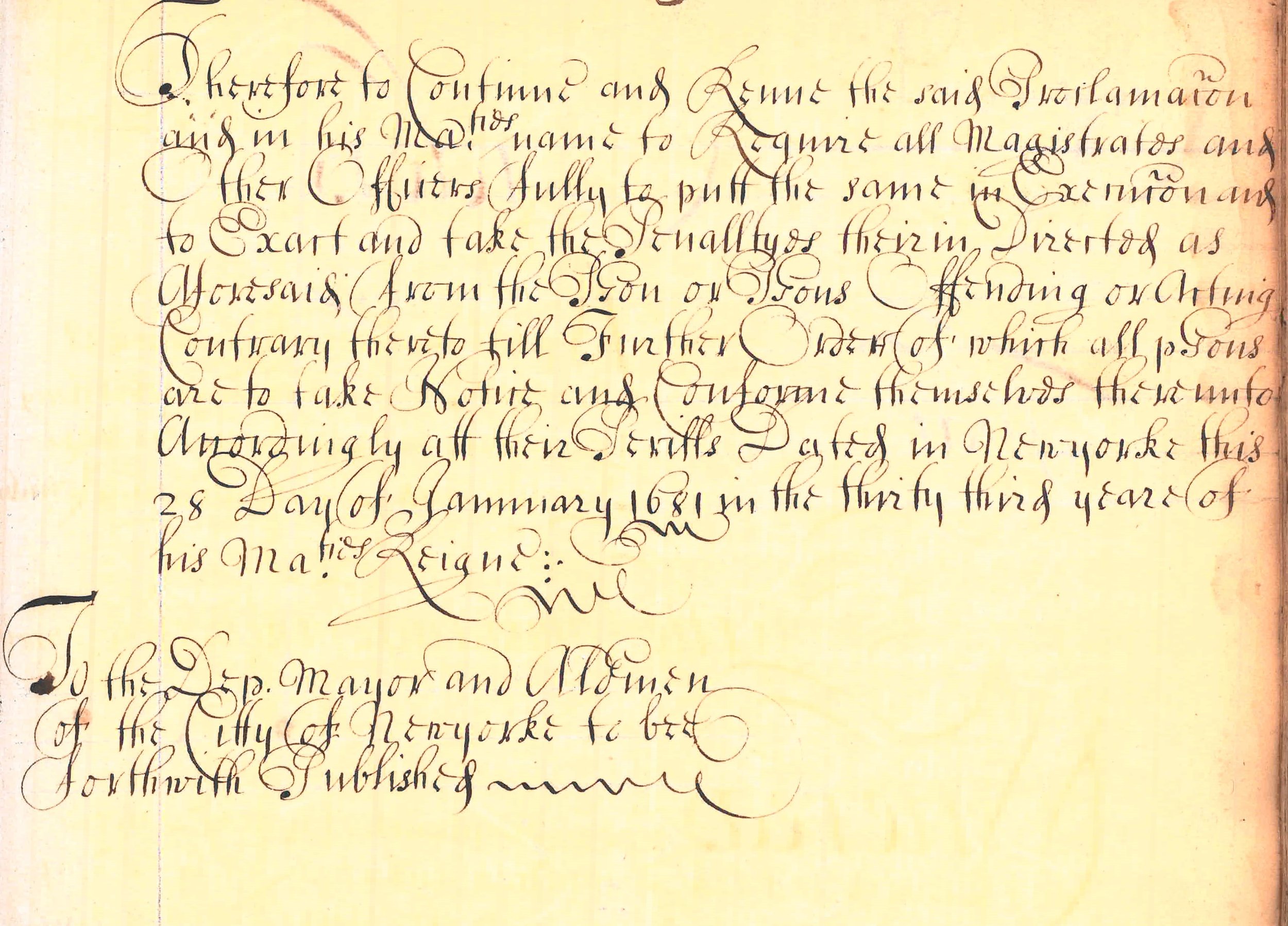
In January 1681, the Council issued a proclamation renewing a former proclamation that prohibited trade with the Indians in their Towns and Plantations. 

Manuscript Minutes of the Common Council, 28 January 1681, page 1 of 2. NYC Municipal Archives.

Manuscript Minutes of the Common Council, 28 January 1681, page 2 of 2. NYC Municipal Archives.

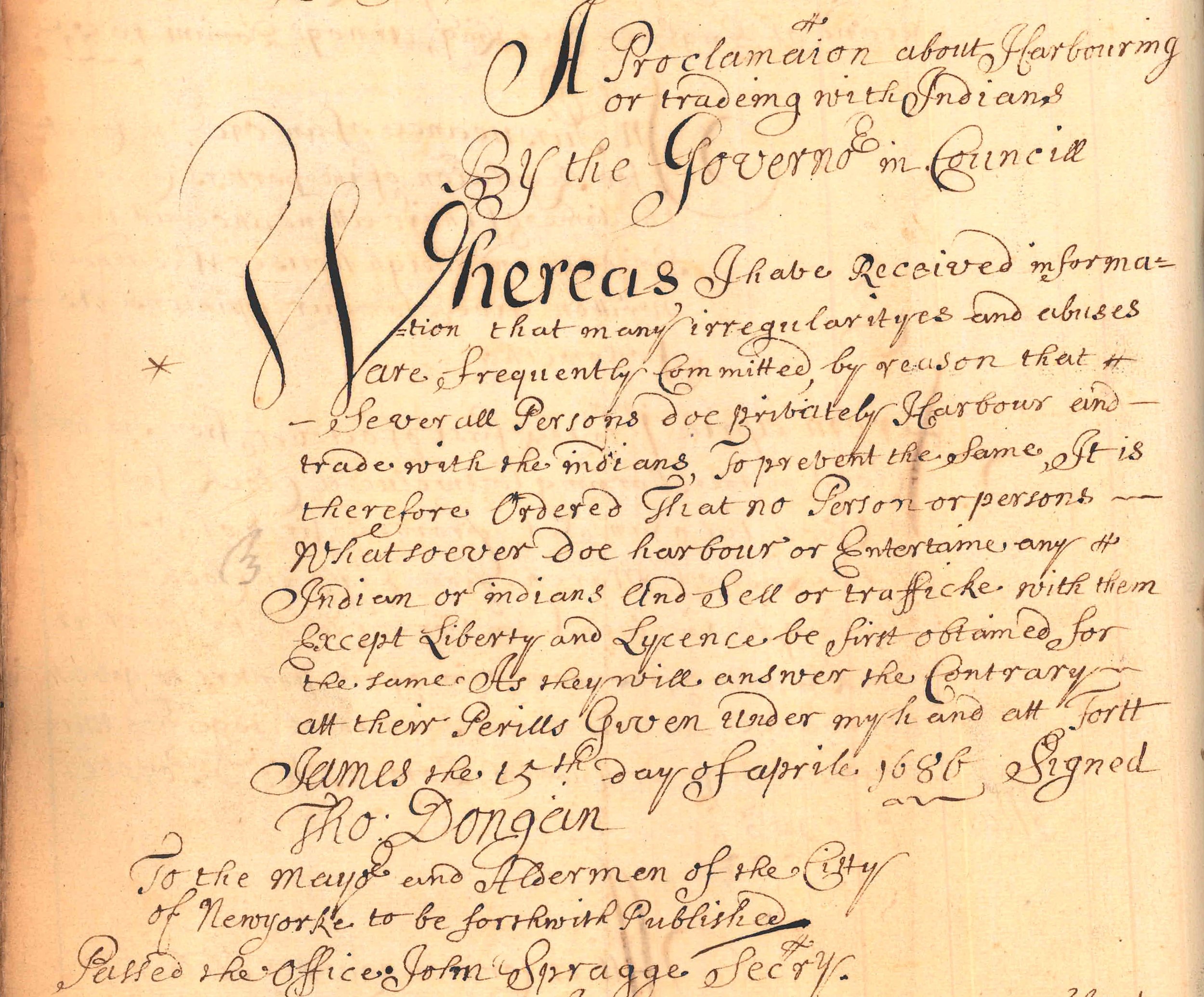
In 1686, the Council again issued a proclamation about “Harbouring or trading with Indians.”   

Manuscript Minutes of the Common Council, 15 April 1886. NYC Municipal Archives.

Look for future For the Record posts to continue the story of the indigenous peoples of New York City.   

Moses v. Tweed

In 1979, the Municipal Archives learned that 23 Park Row, its home for the previous decade, had been sold and would have to be vacated—pronto. Although space in the Surrogate’s Courthouse at 31 Chambers Street had been secured for the Department of Records and Information Services, including the Archives, the necessary renovations were not completed. The solution: move the collections to the “Tweed” Courthouse. It took just a few days in July 1979 for movers to squeeze just about everything maintained at 23 Park Row—all the cartons, maps, ledgers, and the 8,000 Brooklyn Bridge drawings—into several former court rooms on the third floor at Tweed.  

Tweed Courthouse from City Hall Park, February 8, 1938. Department of Bridges/Plant & Structures collection, NYC Municipal Archives.

Almost from the day it opened in 1878, there had been calls for demolition of the Tweed building. Detractors decried it as a too-visible monument to the legendary corrupt “Boss” Tweed or claimed that it overwhelmed the relatively diminutive City Hall. In 1974, only a few years before the Archives residency in the building, a mayoral task force recommended that Tweed be torn down and “replaced with a modest office structure of design compatible with City Hall.”    

This week, For the Record looks at one of these periodic attempts to demolish the structure, this time from the powerful Robert Moses. Recently discovered correspondence in the Archives’ Department of Parks collection documents Moses’ actions in the late 1930s to make Tweed disappear.    

“City Hall Park, the Tweed Court House and the Tombs,” pamphlet, September 18, 1939. Department of Parks General Files. NYC Municipal Archives.

“Please prepare a letter to the Mayor and Board of Estimate on the matter of removing the County Courthouse from City Hall Park…,” wrote Parks Commissioner Robert Moses to George Spargo, one of his deputies, on June 6, 1939. Spargo, as instructed, dutifully drafted a letter, dated June 13, 1939. He got right to the point: “In preparing the 1940 Capital Outlay Budget, we are including a request for the completion of the work at City Hall Park, which brings up the question of the disposition of the Tweed Court House north of City Hall. It is obvious that this should be demolished and the land restored to park use.”  

“City Hall Park, the Tweed Court House and the Tombs,” pamphlet, September 18, 1939. Department of Parks General Files. NYC Municipal Archives.

It is not clear whether Moses sent the letter to Mayor LaGuardia. A penciled notation on the draft said “Hold for plan from Davison.” About a month later, on July 12, 1939, Spargo informed Moses in a memo that “…they won’t be able to start construction [of the new Criminal Courts Building at Foley Square] until 1941. This means that we won’t get the old building out of City Hall Park until 1942.”   

Moses decided he needed additional support for the plan to remove the Tweed building. Using his apparently unlimited budget for promotional materials he prepared an illustrated six-page pamphlet to plead his case. In the first two pages, Moses reproduced a letter to the Mayor. Dated September 18, 1939, it considerably embellished Spargo’s earlier draft. The first paragraph described his overall plan for City Hall Park: “With the completion of the southerly portion of City Hall Park formerly occupied by the old post office building and the removal of the fence around it, the first step will have been taken in restoring this park to the public and in providing an appropriate setting for one of the finest bits of architecture in New York City.” (A recent For the Record article described the saga of the Old Post Office, Bring the 5M With You--Two Eagles and a Post-Office.)  

Moses continued: “The only blot on the landscape which will remain at the end of 1940 if these funds are appropriated, will be the so-called “Tweed” court house. This ugly and obsolete building, a monument to Boss Tweed and Tammany became notorious because of the extravagance and graft linked with its construction. All those interested in the city and its parks are agreed that City Hall ought to be the only building in the park and the department’s plans have been drawn accordingly. The difficulty has always been finding a site for a new court house to take the place of the Tweed building.”  

Moses’ letter went on to describe how Foley Square would serve as the desired alternate site. The pamphlet included an artistic rendering, and a site plan of City Hall Park, minus Tweed. Moses directed Spargo to have 1,000 copies of the pamphlet printed “by the off-set process” for distribution to decision-makers and the press.  

“City Hall Park, the Tweed Court House and the Tombs,” pamphlet, September 18, 1939. Department of Parks General Files. NYC Municipal Archives.

Part of Moses’ plan did come to fruition—a new courthouse, the criminal courts building, opened in 1941 at Foley Square, but somehow Tweed remained. Moses did not give up. In May 1941, he wrote to Benjamin Spellman, a representative of the New York County Lawyers’ Association thanking him for his support for removal of Tweed: “From time to time I have discussed this matter with the Mayor because we are very anxious to get rid of the old Tweed Court House...”.  There was not further correspondence on the subject and apparently Moses abandoned his plan. 

The Municipal Archives remained in Tweed until renovations at 31 Chambers Street were completed in 1984. For the Record related the story of the Archives’ time at the infamous Courthouse in Farewell to Tweed. Although Tweed survived Moses’ attempt to pull it down, that was not  the last time it faced demolition. Look for future articles to continue the story of one of New York City’s most remarkable buildings.